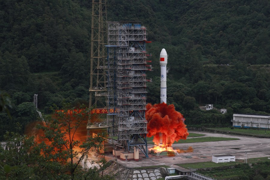
China National Space Administration (CNSA) launched the last satellite of the BeiDou Navigation Satellite System (BDS) from the Xichang Satellite Launch Center in southwest China’s Sichuan Province at 9:43 a.m. on Tuesday (Beijing Time), marking the completion of the deployment of its own global navigation system. The satellite, the 55th in the family of BeiDou that means “Big Dipper” in Chinese, was successfully sent into the preset orbit by a Long March-3B carrier rocket, according to the launch center. The launch mission was a complete success, the center said. Tuesday’s launch was the 336th by the Long March rocket series.
The BeiDou Navigation Satellite System (BDS) is a Chinese satellite navigation system. It consists of two separate satellite constellations. The first BeiDou system, officially called the BeiDou Satellite Navigation Experimental System and also known as BeiDou-1, consists of three satellites which since 2000 has offered limited coverage and navigation services, mainly for users in China and neighboring regions. BeiDou-1 was decommissioned at the end of 2012. The second generation of the system, officially called the BeiDou Navigation Satellite System (BDS) and also known as COMPASS or BeiDou-2, became operational in China in December 2011 with a partial constellation of 10 satellites in orbit.
In 2015, China launched the third generation BeiDou system (BeiDou-3) for global coverage. The first BDS-3 satellite was launched on 30 March 2015. On 27 December 2018, BeiDou Navigation Satellite System started providing global services. The 35th and the final satellite of BDS-3 was launched into orbit on 23 June 2020. When fully completed, BeiDou will provide an alternative global navigation satellite system to the United States-owned Global Positioning System (GPS), the Russian GLONASS, or European Galileo systems. It was said in 2016 that BeiDou-3 will reach millimeter-level accuracy (with post-processing).
There are two levels of service provided – a free service to civilians and licensed service to the Chinese government and military. The free civilian service has a 10-metre location-tracking accuracy, synchronizes clocks with an accuracy of 10 nanoseconds, and measures speeds to within 0.2 m/s. Similar to the other global navigation satellite systems (GNSSs), there will be two levels of positioning service: open (public) and restricted (military). The restricted military service has a location accuracy of 10 centimetre, can be used for communication, and will supply information about the system status to the user. To date, the military service has been granted only to the People’s Liberation Army and to the Pakistan Armed Forces.